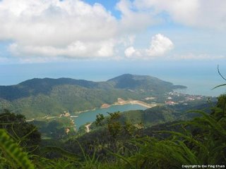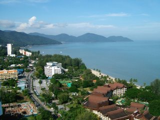
Any one interested to hike from Teluk Bahang Forest Park To Penang Hill? Look at this
photos taken by some hiker, i remember during my Form 6 in
PFS, we joined the hiking trip organised by PFS form 6 teachers. That trip is not the toughest one, average i will say, Trail 3 maybe according to
Penang Forest Department. Kindly let me know if you are interested to join, to enjoy the beauty of Penang's nature, to escape from the pressure of working, so me can plan some day this year to hike from there to Penang Hill...
There are a total of five trails. They are all open to the public at no charge and each is planned according to different levels of difficulty. The four listed below all start from a common point and then divert onto different points within the forest reserve. Hikers need not worry about getting lost because the trails are marked with clear signs giving short explanations or story lines at 21 stops.
Level 1. Monkey-Cup Forest Trail
(Distance: 800 metres, Duration: 1 to 1.5 hours, 5 station stops)
This short and easy trail, suitable for all age groups, allows trekkers a glimpse of the flesh-eating plant known as the monkey cup or pitcher plant in English, or pokok periuk kera in Malay. Botanists describe the pitcher plant, which belongs to the Sarraceniaceae family, as having leaves modified into pitchers in which insects are trapped and digested by means of liquids secreted by the leaves. The plant is harmless however and some people in Sarawak even use the plant to cook rice in. Other uses of the pitcher plant are in the treatment of high blood pressure, diarrhoea, cough and fever.
Other trees along the trail are the nyatoh taban merah (the sap was once used as a colouring agent), the meranti melantai, keruing (its resin is used as a base for ointments, perfumes and paints), bertam, the calophyllum sp. (this plant holds a potential cure for AIDS, says the Forestry Dept) saga, kapur and rengas kerbau jalang (the tree produces an irritating black sap).
Level 2. Simpoh Gajah Trail
(1,240 metres, 2 to 2.5 hours, 7 station stops)
This trail is described as of average difficulty and is recommended for all ages. It is similar to Trail 1 but hikers pass through an area designated as virgin jungle reserve. This trail is named after the simpoh gajah, a tree whose stilt roots resemble the shape of an elephant's trunk. An interesting feature of this tree is the hissing sound it makes when its bark is cut. Trekkers get to see such a tree during the hike.
Level 3. Charcoal Kiln Trail
(2,980 metres, 3 to 4 hours, 10 station stops)
This trail is described as requiring some strenuous uphill walking and is recommended for physically fit trekkers. It takes you up to an altitude of 150m above sea level. Some of the plants hikers get to observe and learn about are the bayan, a species of palm which is used as food, the famous tongkat ali, gajah beranak, kacip fatimah, selaganilla, petai (a pungent pod), a big climber, commercially viable trees and a charcoal kiln built in the 50s.
The tongkat ali, also known as the local ginseng is taken as a health supplement, lowers high-blood pressure, and also serves as an aphrodisiac. Both gajah beranak and kacip fatimah are taken by women during post-natal recovery and for general good health. Petai is a popular ingredient in Malay and Nonya cooking. It can be eaten raw or cooked and is widely believed to have cleansing properties.
Level 4. Ridge Top Trail
(4,280 metres, 4 to 5 hours, 10 station stops)
This trail is categorised as demanding. This means that unless you are physically fit or have lots of stamina, you should not attempt this. Like Trail 3, this trail includes some steep hill climbing.described as requiring some strenuous uphill walking and is recommended for physically fit trekkers.
It follows Trail 3 until you pass the bayas palm, ascend upwards to 150 metres, then branch off eastward and ascend some more until you reach an altitude of 400m, or the ridge of the hill. You pass some pitcher plants before reaching an open area which overlooks a panoramic view of Telok Bahang. Then you head back towards the Forest Park via a buffalo logging trail.
Penang Hill Forest Challenge
(11.3 kilometres, 8 hours, 10 station stops
between Recreational Forest and Penang Hill) - Trail 5
This forest trail, called the Penang Hill Forest Challenge, is developed by the State Forestry Department. It starts at the Forest Park, winds through eight stops before reaching Bukit Laksmana and the permanent forest reserve. After reaching Western Hill, you continue your hike on a tarred jeep track until you reach the Upper Railway Station. From there you can use the jeep track to descend to the Botanical Gardens or Air Itam town (via Hye Keat). If you are too tired to walk down, you can always use the funicular railway. Apparently there are two ways of tackling this challenging trail. One is the tough version, which starts from the Forest Park and involves an uphill climb all the way. The other is the easier version, which starts from Western Hill and goes downhill until you reach the Forest Park. The distance between the Forest Park and the Penang Hill Top Station is approximately 11 kilometres.
Forest hikes are undeniably the best way of enjoying and appreciating natural wonders. Any number of people can participate and it doesn't cost very much. If you want to set up camp, it may be advisable to organise a team as heavy loads need to be carried over long distances. Don't forget to inform the friends/relatives before embarking.
For further enquiries, contact:
Pejabat Perhutanan Negeri Pulau Pinang
Tingkat 20, Menara KOMTAR, 10000 Pulau Pinang
Tel: 604-262 5272, 650 5250 • Fax: 604-263 6335
Pejabat Renjer Hutan Telok Bahang: 604-885 1280
Museum Perhutanan Hutan Lipur Telok Bahang
Taman Rimba, Telok Bahang, 11050 Pulau Pinang
Tel: 604-885 2388 • Email: jabatanp@sukpp.gov.my
The Forestry Museum is opened every day except on Eid-al-Fitr (Hari Raya Puasa) and Eid-al-Adha (Hari Raya Haji).


